http://www.milsurps.com/showthread.php?t=26665
點擊上面鏈接閱讀詳細內容。 稍後我們將編輯轉發。
點擊上面鏈接閱讀詳細內容。 稍後我們將編輯轉發。
| 友情提示,本网站为枪友会员专用,内容涉及枪械,射击,渔猎,户外活动等专业内容,不适者勿入!非喜者勿入! 未满18岁勿入! |
|
Written by Strathglass--CanadianGunNutz How To Find Ontario Crown Land to Shoot On A lot of people ask where can they shoot their gun in Ontario. Usual answers will include “crown land”, sometimes with a reference to the MNR web site, but otherwise with no real details on how to identify such land. So here I will attempt to explain in some detail how to find such areas because I think a lot of people are not clear on all these details. Links for the web sites mentioned here are listed at the end. The Ontario Ministry of Natural Resources has a web site that documents the Crown Land Use Policy Atlas (CLUPA). Using this web site, which covers a lot of the province, you can find details on the location and classification of the various crown lands in the province. (The far north, as well as southern Ontario are not yet covered.) What you want to do is identify crown land that is classified as a “General Use” area – these areas are shown in yellow on the MNR CLUPA maps. Sometimes there will be diagonal lines overlaid: these indicate overlay areas which modify the rules for that area in some way. I just tend to look for areas that are all yellow without the overlay marking (then I don’t have to look up the additional restrictions associated with the overlay area). Once you’ve picked a suitable spot, the website lets you get the land use report for that area: you need to look at this to see what the specific land use intent there is for that GUA (General Use Area), to make sure it is suitable for what you want to do (shooting). Ultimately you need to find an area that is: 1,Conveniently located for you (as much as possible) 2,Big enough to safely shoot on (in any event you will have to find a spot that has some kind of backstop) 3,Accessible – you can’t trespass on private property to get to crown land! OK, enough words … lets walk through an example, with images: When you start the map browser (link below), the top level map will look like this: FIGURE 1  OK, that looks promising, lots of yellow not too far from the GTA. But when you zoom in you see more detail and it does not look as good: FIGURE 2: 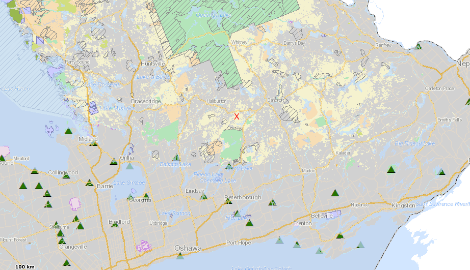 But that is what you have to work with! So lets work with it...say we want to pick a spot near the red X that I have marked in the above figure, which is close to the hamlet of Tory Hill, and south of Highway 118. You can zoom in and see the image below (notice the legend at the left, which shows that yellow is for the General Use Areas [to get the legend to be visible you first have to click the "Map Layers" tab, then the "Legend" button]): FIGURE 3: 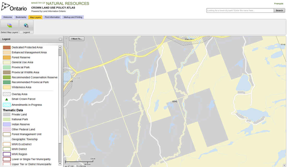 OK, we can see some roads going through the general use crown land (the yellow areas), and this crown land is of pretty decent size (see scale at bottom left), good! What you need to do is pick a specific spot you want to try and use and get the details on it thusly (the numbers refer to the markup in the image below): (1) click on the “Find Information” tab and then (2) click the “Get Land Use Information” button (“i” symbol): after doing this you can use the mouse to (3) click on a spot on the map to get the details for that area. Below is the result for a spot that I selected, where you can see that the web page shows (4) the primary land use summary information (this area is identified by policy ID G342, which can also be seen as a label on the map), with (5) a link to the land use report: FIGURE 4: 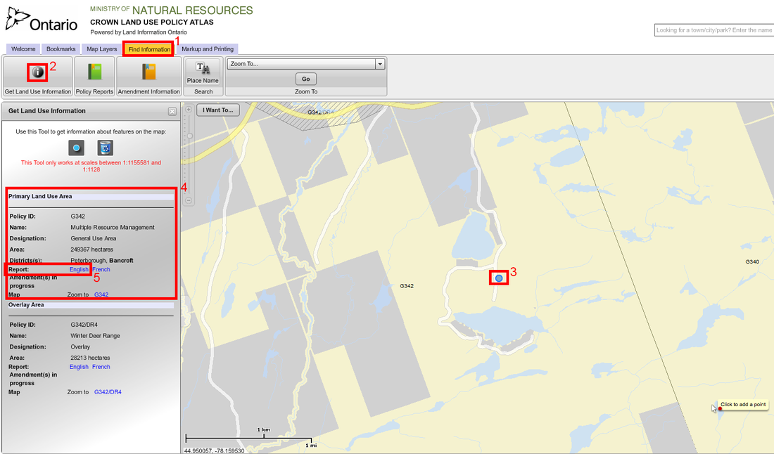 Notice the spot I picked (3) has lots of crown land to the east - at least a couple miles show on the map. If you click on the land use report link (see the item marked (5) in the above figure), a new page will open with the land use report. It looks like the image below, and if you scroll down you will see if the allowed recreational uses include hunting. Here, it DOES include hunting. That means you are good to use it for shooting!! (You need to be aware of the hunting regulations [so you need to figure out the WMU this area is in], best bet is to at least have a small game licence, or to have target shooting stuff – and set those up before you uncase your gun). Here is the land use report marked up to show how it indicates that hunting is allowed: FIGURE 5: 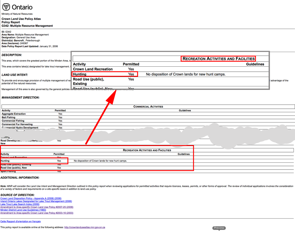 That’s pretty much it – the basics at least. Except for a couple last tips: TIP #1 Going back to the map view, you can get GPS coordinates of spots of interest as follows (with references to the markup in the image below): (1) click on the “Markup and Printing” tab, then (2) click on the “Add Pushpin” button, then (3) click on the “Label with map coordinates” checkbox, then if you click on spots on the map – e.g. (4a) and (4b) – a pushpin is drawn showing the GPS coordinates. In this example I’ve located the same spot as selected in the above diagram (the spot we want to park – (4b)), and also the spot on highway 118 we need to turn off at – (4a): FIGURE 6: 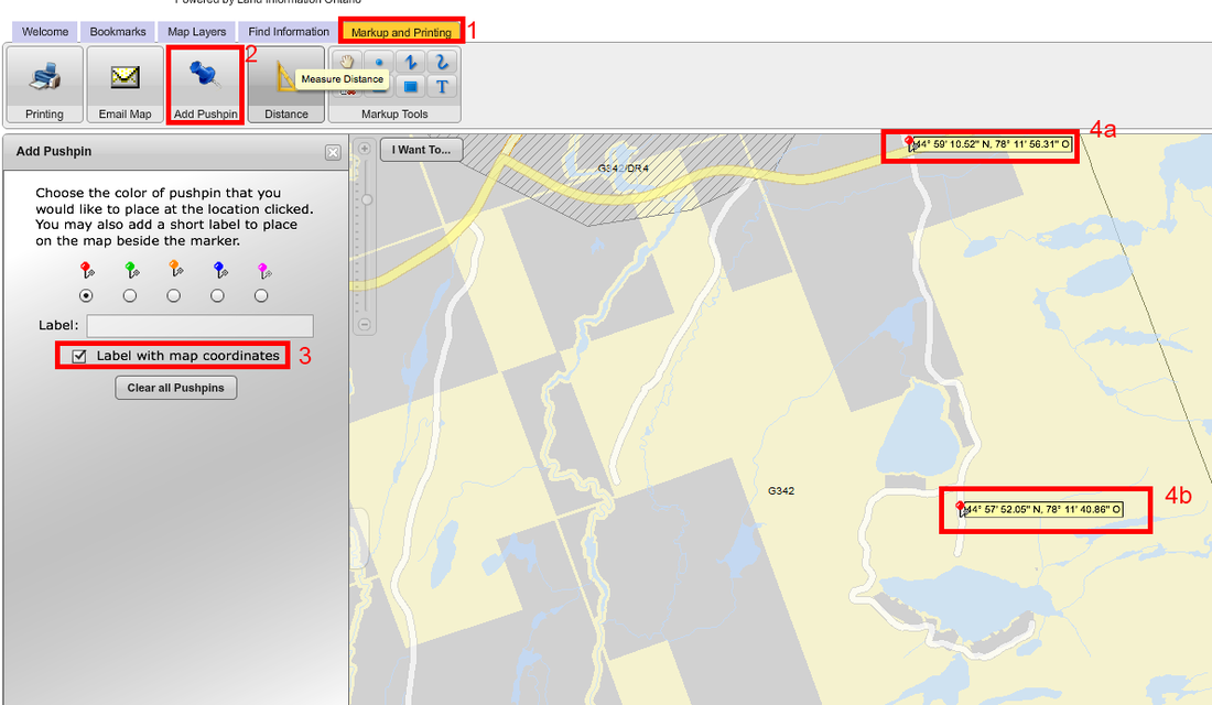 TIP #2: The CLUPA maps do not show topographical detail. However MNR's LIO (Land Information Ontario) web site (see links at bottom) uses a similar kind of map interface to let you see a topopgraphical map view of any part of the province. You can use this other Government of Ontario website to get a topographical view of your area of interest: this can help you make sure you pick an accessible spot, and to understand what the terrain will be like (how hilly, swamp locations, etc.). Below is the image from the MNR LIO website (topographical view) showing a close up of the selected area we've been using in this example (I've marked with a blue circle the same spot as selected above): FIGURE 7: 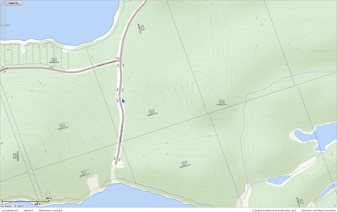 DISCLAIMER – I make no claims regarding the accuracy of any of the information in this post. Use at your own risk! (Corrections welcomed.)
LINKS: Ontario Crown Land Use Policy Atlas – main page: https://www.ontario.ca/environment-a...e-policy-atlas (short link: http://goo.gl/JMcDUf) Ontario Crown Land Use Policy Atlas – map viewer: www.giscoeapp.lrc.gov.on.ca/web/MNR/NHLUPS/CLUPA/Viewer/Viewer.html (short link: goo.gl/EaBtEZ) Land Information Ontario (LIO) Main web site: http://www.ontario.ca/environment-an...mation-ontario MNR's LIO Topographic Map maker web site: www.giscoeapp.lrc.gov.on.ca/web/mnr/gib/basedata/viewer/viewer.html Additional Info: For hunters, Ontario Ministry of Natural Resources and Forestry WMU (Wildlife Management Unit) maps are available here:http://www.ontario.ca/environment-an...t-unit-wmu-map (Short link: http://goo.gl/jLI44g) PineMartyn on Youtube has a good pair of videos that elaborates on this stuff more generally: goo.gl/X3y8Q4 (Crown Land Camping & Hiking: What is it and why do it?) goo.gl/A5HuFh (Crown Land - Part 2: How to find crown land in Ontario) EDIT#2: 20140901 - Links updated (required due to Ontario government web site changes). Last edited by strathglass; 09-01-2014 at 09:08 AM. Reason: Updated some government of Ontario URLs, added WMU map link. I should add that I am not sure if the by-laws of the local township containing the crown land apply to the crown land itself or not. To be safe, it would be good to look up the township's bylaws to see if there is anything relevant you need to be aware of (noise bylaws - they might impact time of day you can shoot; no-shooting bylaws-maybe you can't shoot on Sunday, etc.). (Or give them a call.) Wikipedia has an article listing all the municipalities in Ontario here: List_of_municipalities_in_Ontario. The Ontario Government has a website too that I've used, but it is down right at this moment. [UPDATE: back up now...it is at www.mah.gov.on.ca/Page1591.aspx] If for example you were looking at Crown Land in the township of Havelock-Belmont-Methuen, you could find the by-laws by googling for the township web site (it is available via the above Wikipedia page), and then finding their by-laws on their web site. In the case of Havelock-Belmont-Methuen, you would end up at this web site: www.havelockbelmontmethuen.on.ca/bylaws.php (I leave it as an exercise for the reader to figure out which township contains the Tory Hill example spot above, and what the by-laws are for it.) Last edited by strathglass; 12-08-2013 at 10:53 AM. Thanks Strathglass's great job! -TCGC |
AuthorWrite something about yourself. No need to be fancy, just an overview. Archives
October 2015
话题分类
All
|
 RSS Feed